Page 9 - May 2014 - The Chehalis Tribal Newsletter
P. 9
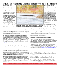
Why do we refer to the Chehalis Tribe as “People of the Sands”? History of the River History of the People The Chehalis River originates Why do the Chehalis People refer to in several forks in southwestern ourselves as “People of the Sands”? Washington, fowing east, then north, “Sands” has several meanings, with then west, making a large curve one referring to the sandbars that before emptying into Grays harbor , come and go with the foods that and estuary of the Pacifc Ocean. occur on the river. Many villages were built along the bank where “The Chehalis River begins at the sandbars appeared. It was good confuence of the West Fork Chehalis place to fsh as the water became River and East Fork Chehalis River, shallow and weirs could be set up in southwestern Lewis County. to harvest the upcoming fsh runs. From there the Chehalis fows Another explanation is that sand is north and east, collecting tributary gritty. Our ancestors had a lot of grit streams that drain the Willapa to overcome and survive whatever Hills and other low mountains of came their way. southwestern Washington. The South Fork Chehalis River joins the main The Confederated Tribes of the river a few miles west of the city A photo of a sand bar on the Chehalis River. Sand is lighter than Chehalis Reservation is made of fve of Chehalis. The Newaukum River rocks and gravel which is easily moved when the river floods. different bands (Upper and Lower joins the Chehalis River at Chehalis, Chehalis, Upper and Lower Cowlitz after which the river turns north, fowing by the city of Centralia, where and Athapaskans bands of the Kwalhioqua (Willapas) of the Pe Ell, Doty, the Skookumchuck River joins. After Centralia, the Chehalis River fows Dryad area). Our ancestors fshed, gathered, and hunted from the Columbia north and west, collecting tributaries such as the Black River, which drains River to Mud Bay, returning to permanent villages along the Chehalis the Black Hills to the north, the Satsop River and Wynoochee River, which River once they had secured food and the materials they needed. One large drain the southern part of the Olympic Mountains. village, known as the Westports, was located along the Lower Chehalis basin in Grays Harbor. This is where tidal sands were located and the true The Wynoochee River joins the Chehalis near Montesano, after which reference to the name “People of the Sands.” the Chehalis River becomes increasingly affected by tides and widens into Grays Harbor estuary. The city of Aberdeen lies at the mouth of the Community History of the City of Chehalis Chehalis River. Just east of Aberdeen, the Wishkah River joins the Chehalis, and just west, between Aberdeen and Hoquiam, the Hoquiam River joins. The City of Chehalis’s beginnings can be traced back to the summer of At this point the river has become Grays Harbor. Before the estuary of 1851. The Saunders family staked out a 640-acre land claim, which is now Grays Harbor empties into the Pacifc Ocean, the Humptulips River joins.” downtown Chehalis. On May 8, 1859, Saunders established the frst post See http://wa.water.usgs.gov/projects/chehalis/ offce in the community he had named Saundersville. This Chehalis River is the second largest watershed within Washington, In 1870, the name was changed to “Chehalis,” an Indian word meaning covering over 124 miles. Although the river is primarily spring-fed, there is “shifting and shining sands.” However, the name change was not one dam that was built near Centralia on the Skookumchuck River in 1970. recognized by the territorial legislature until 1879. See History of Chehalis, Washington. City of Chehalis. http://ci.chehalis.wa.us/cityclerk/history- Historically, our ancestors used the waterways as highways to travel to and chehalis-0 from villages and to trade with other tribes and white setters. They used shallow shovel-nose canoes to harvest, travel, and to sustain their families. References The river provided a major source of food, with several species of salmon, Adamson, T. (1926–1927). Unarranged sources of Chehalis ethnology. steelhead, and eels migrating upstream and back to the ocean. In addition, Melville Jacobs Collection, University of Washington Special Collections, there was an abundance of freshwater clams and crayfsh. Seattle, WA. The Upper and Lower Chehalis people resided along the rivers to harvest Neilson, H. (1970). Focus on the Chehalis Indians, 1800-1900. fsh, wild game, plants, and berries to provide for their families. Some Unpublished M.A. thesis, Pacifc Lutheran University, Tacoma, WA. families built summer camps along the creeks, though they had larger long houses for the winter months. Our ancestors knew where the high ground Marr, C., D. Hicks, and K. Francis (2001). The Chehalis People. Ed. was and were able to avoid the annual foods that have occurred on the Richard Bellon. Cultural Research Project, Confederated Tribes of the Chehalis River for generations. Chehalis Reservation, Oakville, WA. chehalistribe.org greatwolfodge.com luckyeagle.com eagleslandinghotel.net Page 9