Page 10 - Chehalis Tribal Newsletter in January, 2016
P. 10
10
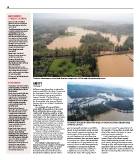
IMPROVEMENTS The flood relief bridge on South Bank Road was completed in 2013 to help alleviate flooding issues.
TO PREDICT FLOODING
SAFETY Floodwaters surround the Black River Bridge on Howanut Road in the Chehalis Valley
Proposed actions by Mark during the last flood.
White, Department of Natural From page 1
Resources director, after the different ways, depending on where the you find yourself confined on our little drown, turn around” is a good tip for all
recent flood: hardest rains fall in the basin. Sometimes island. In such instances, make sure you to remember. It jeopardizes your life and
“Install flood monitors so that we the headwaters flood and other times have enough emergency supplies to last those of the people that come to rescue
can better predict road closures the tributaries in one area or another the duration of the emergency. Other you if you become stranded.
and flooding levels. These become flooded. The Black River, natural disasters such as earthquakes,
would be ultrasonic sensors which converges with the Chehalis on volcano eruptions, fires and snow impact Road closed signs are there for a
that will read water levels every the Reservation, also rises and floods, everyone in our region. Each household reason. Please do not drive around
five minutes and electronically however there are no flood-monitoring can make their own preparations in the them. Besides placing yourself in direct
transmit the data so that tribal gauges on it. event of a flood or other emergencies by peril, driving through floodwater causes
government and tribal business assembling an emergency supply kit. damage to your vehicle that might not be
managers can see real-time One example of how each flood immediate and can lead to costly repairs.
flooding and predictions of road event differs from another is the recent Stay put until the water recedes. It You also might have to pay a traffic fine of
closures as a flood comes.” flood with heavy rain in Lewis, Grays is highly recommended not to drive $423 for something that could have been
Three things this would Harbor and Thurston counties, as well through the water. The saying, “Don’t avoided.
accomplish: as in other counties throughout western
Better data of localized Washington. The floodwaters were rising
flooding to create improved at a fairly steady rate when they had an
models for predictions. unforeseen increase. Determining when
Create a live feed flood possible flooding would occur on local
inundation map to monitor roads also was complicated because of
what roads have water on them the river’s flood gauge near Centralia
and at what depth. became stuck at one level for a few hours.
Operate businesses more
efficiently during a flood and be Because of these varying factors,
able to keep them open longer Reservation residents are urged to keep
with a safety margin and reopen an eye on the river levels and monitor
as soon as possible. local media reports even if the rain has
The process for this already has stopped and all other local rivers have
been initiated. receded.
FLOOD STAGES The Chehalis Tribal Emergency
Management team continues developing
According to Thurston County’s plans to assist and protect our Tribal
Flood Preparedness information residents. Fortunately, most homes
for the Chehalis River at Grand have been built above the flood plain
Mound gauge: though there might be periods where
Flood stage is about 12.5 feet:
The Chehalis River will flood
several roads in Independence
Valley including James Road,
Independence Road and Moon
Road. Floodwaters also will
cover nearby farmlands and
low-lying roads.
Moderate flood stage is
about 15.5 feet: The Chehalis
River will flood several roads
in Independence Valley with
swiftly moving water including
James, Independence, Moon,
Howanut and possibly Anderson
Roads. Floodwaters could
inundate nearby farmland.
Some residential structures
might be threatened
Major flood stage is about
17.5 feet: The Chehalis River
will cause major flooding,
inundating roads and farmland
in Independence Valley. Deep
and swift floodwaters likely will
cover State Route 12, cutting
off access to the Chehalis
Reservation. Flooding will occur
all along the river including
headwaters, tributaries and
other streams within and near
the Chehalis River Basin.